
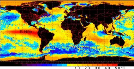
China’s National Climate Centre is warning that a strong to “super” El Niño could develop as sea temperatures in the central and eastern tropical Pacific continue to rise. In June, temperatures in the key monitoring region were already around 1.6°C above average, up 0.64°C from May, and forecasters expect the warming to continue through the summer and autumn. El Niño is a natural climate pattern caused by unusually warm Pacific waters, but a very strong event can disturb weather systems across the world. For China, scientists are watching closely because it could bring heavier rainfall and flooding in some regions, stronger heatwaves and greater weather uncertainty extending into 2027.
The concern is not limited to China. A powerful El Niño can shift rainfall, temperature and storm patterns across Asia, Australia, Africa and the Americas, affecting agriculture, water supplies, fisheries and energy systems. The World Meteorological Organization has also warned that unusually warm subsurface Pacific waters are helping fuel the developing event, while global forecasts now suggest the 2026–27 El Niño could become one of the strongest ever recorded. A particularly intense El Niño could also push global temperatures higher, adding another layer of pressure to a planet already experiencing record heat. For countries that depend heavily on predictable rainfall, the message is clear: the Pacific is warming, and what happens there will not stay in the Pacific—it could influence food production, water security and extreme weather across the world. More